Purpose of the project: The goal of the Bear River Estuary Restoration was to rebuild a healthy, functioning natural estuary for anadromous fish including chum, coho, and Chinook salmon and cutthroat trout; migratory waterfowl and shorebirds; and to contribute to the overall health of Willapa Bay. This 500-acre restoration supports local watershed and salmon recovery efforts, migratory bird management and helps to increase the resiliency of Willapa Bay to sea-level rise.
Purpose of the project:
The goal of the Bear River Estuary Restoration was to rebuild a healthy, functioning natural estuary for anadromous fish including chum, coho, and Chinook salmon and cutthroat trout; migratory waterfowl and shorebirds; and to contribute to the overall health of Willapa Bay. This 500-acre restoration supports local watershed and salmon recovery efforts, migratory bird management and helps to increase the resiliency of Willapa Bay to sea-level rise.
Background:
When non-Indian settlers first arrived in the region, Willapa Bay comprised 14,620 acres of saltwater wetlands. Now there are 5,277 acres. This represents a 64% loss of estuarine wetlands (Coastal Resources Alliance 2007). Estuarine wetland loss has been particularly extensive in the Bear River estuary, primarily due to diking and draining of shallow water nearshore areas. The salmon recovery strategies of each of the Lead Entity groups in the Coast Region make it clear that problems for salmon caused by shoreline modification, such as diking and armoring, are top priorities to address (WCSSP 2012). The removal of existing dikes and re-establishment of estuarine rearing habitat for juvenile salmonids was identified as a high priority in the Pacific County (WRIA 24) Strategic Salmon Recovery Plan (Applied Environmental Services 2001). The protection and restoration of estuarine and nearshore habitats were also cited as major ecoregional recovery goals in the Pacific Northwest Coast Ecoregional Assessment (TNC and WDFW 2006), the Northern Pacific Coast Regional Shorebird Management Plan (Drut and Buchanan 2000), and Pacific Marine and Estuarine Fish Habitat Partnership Strategic Framework 2012–2017 (PMEP 2012).
Historically chum salmon were the most dominant in Willapa Bay, 65% of the total run. This is reflective of our habitat in Willapa Bay’s 745 salmon-bearing streams, with 1470 miles of salmon habitat. Many of the streams in Willapa Bay are low-gradient streams that empty directly into the estuary. Changes in land management and fish management practices over the years have almost eliminated the chum salmon in Willapa Bay. The large chum population was targeted for harvest by fish traps, and sets, from the turn of the 19th century until 1935. Staring in the 1950’s commercial gillnetting, with the use of the monofilament nets harvest salmon/sturgeon, until 1998, when Washington State Department of Fish and Wildlife, closed the Bear River for commercial harvest because the salmon population was very low. In 2009, the run size is less than 1% of the total salmonids. In Willapa Bay historically the natural spawning populations of anadromous fish have been: 65% chum; 25% coho, and 10% Chinook. Other anadromous cutthroat trout, steelhead, but there is no reliable data on their populations; all have been experiencing sharp declining populations.
During the 1950s, a large portion of the salt marsh habitat present in Bear River estuary was eliminated by the construction of several miles of a dike that ran parallel to the southern shoreline of Willapa Bay. The dike disrupts physical, chemical and biological processes associated with tidally influenced areas; acts as a barrier to the movement of sediment, organic material, and aquatic organisms; and reduces the survival and productivity of several species, including chum, coho, and Chinook salmon, and cutthroat trout, that formerly spawned and/or reared in the diked-off areas.
Resident non-anadromous populations of cutthroat trout were captured in Lewis and Porter Creeks in 1999 (Barndt, et al. 2000); the same survey reported that the two streams contain 2.5 miles of potential spawning and rearing habitat. Fish ladders were installed in the dikes in 2001 to enable fish to access Lewis and Porter Point during times of the year when tides were high. As a result, a small run of coho was re-established in Lewis Creek (USFWS 2011).
Goals and objectives: The goal of the project was to restore a large area of the Bear River estuary that had been degraded by past human activities to a healthy, naturally functioning condition. The Bear River Estuary Restoration project removed 5.16 miles of an existing dike, 38 culverts, 2 fish ladders, two tide gates, two footbridges, and many culverts. As a result, nearly 204 hectares (500 acres) of estuarine habitat has been restored, including 91.5 hectares in16 tidal channels that convey water from upland and tidally-influenced areas directly to Willapa Bay. Reestablishment of natural estuarine processes and habitats benefit a diverse array of aquatic and avian species, including marine invertebrates, salmon and trout, shorebirds, and waterfowl, with corresponding ecological and economic benefits.
The primary focus is juvenile salmonids for rearing; and for sturgeon and eulachon (candlefish), which are listed as threatened for habitat in this watershed. The entire area was blocked by dikes in the 1950s, which destroyed the function of the estuary. Strategic planning for restoration stated in 1999, and 11 Strategic plans and studies were completed in the watershed to define the plans for restoring the estuary. The streams flowing into the estuary were restored for spawning and in-stream rearing first. The last stream completed in 2010. The missing element in the juvenile life cycle is estuary rearing for salmonids making their transitions to saltwater. This project provided that necessary element.
Restoration and enhancement of estuarine habitats will increase the acreage of salt marsh and other habitats, including the tidal creeks, eelgrass beds, and channels that furnish young salmon (coho, chum, Chinook, and cutthroat trout), with protected feeding areas where they forage and grow before heading out to sea. Lewis and Porter Point streams also provide spawning habitat for cutthroat trout and coho.
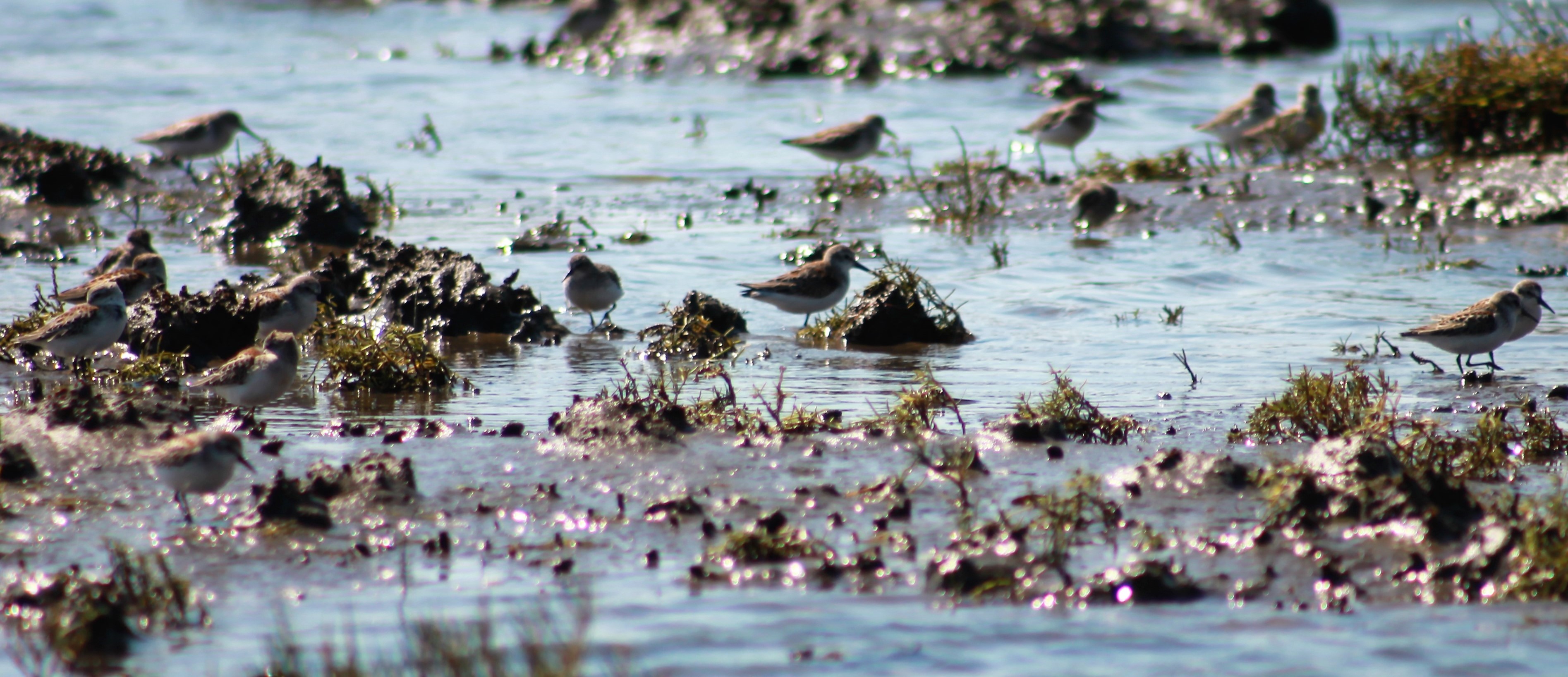
Migratory waterfowl, waterbirds, and shorebirds are also expected to benefit from the increase in tidal marsh and mudflat habitat. Estuarine areas on the Refuge have annually provided important habitat for over 20,000 migrating ducks, tens of thousands of shorebirds, and 3,000 migrating geese at a time. This type of habitat is essential to sustaining the estimated 2.2 million duck, 400,000 Canada goose, 200,000 brant, and over 2 million shorebird use-days associated with the southern half of Willapa Bay (USFWS 1997).
Human Interest/Community Benefit:
Access to the Willapa National Wildlife Refuge has changed since the Bear River Estuary Restoration began. Many new opportunities (trails, hunting areas, boat access, etc.) have been created. Tens of thousands of visitors annually discover more about the ecology, wildlife, and management of the Refuge. These areas also provide an outdoor classroom for the Refuge’s Environmental Education Program provided each spring by the Friends of Willapa National Wildlife to all the 4th-grade students in Pacific County, Washington. Students experience and learn from the unique habitats and native wildlife showcased along the trails, including 500 acres of Bear River Estuary restoration.
In addition to the 500-acre Bear River Estuary Restoration, the Refuge completed another 250-acres of restoration in Willapa Bay (see attached map) which enhance salmon recovery efforts, migratory bird management and help to increase the resiliency of Willapa Bay to sea-level rise. In 2013, 49 acres of the estuary at Tarlatt Slough on Washington Department of Transportation property was restored by removing a dike and reconnecting tidal channels. In 2015, the Refuge restored another 149 acres of estuary and removed the last remaining fish barrier to the 2,317-acre watershed, restoring fish passage to ten miles of streams on the Refuge at Greenhead Slough.
Summary:
The Bear River Estuary Restoration project was completed in six years by the staff of Willapa National Wildlife Refuge (WNWR) with assistance from NDC Timber. Restoration in the Lewis Unit (Phase 1, 160 acres) was completed in 2012, and Porter Point Unit (Phase 2, 140 acres) was completed in 2013-2014. In these first two phases, two fish ladders, two culverts, and over three miles of the dike were removed; thirteen historic streams/channels were reconnected, and 300 acres of the estuary has been restored. Phase 3 & 4 involved maintenance of the existing Parker Slough dike which was completed in 2017. Phase 5 of the restoration was completed in 2018. Approximately 1 mile of the Riekkola dike, two tide gates, and two culverts were removed; 200 acres of the estuary was restored; three historic tidal channels were reconnected, and the western 2,000 feet of the dike that remained as part of the Refuge’s South Bay Trail was improved for public access.
2009
Survey work began. The entire area was flown with Light Detection and Ranging (LiDAR) to obtain a detailed map. Then a ground survey cross-section of the dikes and roads was made as an aid to designing the removal of the dikes/roads. These two databases were then combined which produced the overview map of the area. The cross-sectional surveys resulted in a database that defined the soil mass to be removed and fill required.
2010
With funding from Washington State Salmon Recovery Funding Board, WBRFEG, and in-kind design development was started using a design team method. Twenty design team members from WNWR, Washington Department of Fish and Wildlife, Washington Department of Ecology, Pacific County, University of Washington, and AMEC Earth and Environmental (AMEC) were the lead design group, and WBRFEG the project sponsor/leader. The design was developed by first developing a Basis of Design document, which all team members agreed upon. This was followed by a series of design reviews, which all design team members attended and agreed upon. In parallel with this activity, a Monitoring Protocol was developed by AMEC. The design was completed in August 2010, and a Biological Evaluation (BE), which included the ESA, historical and archeological determinations, was started. Baseline monitoring was completed in September. The BE report was completed, and an application to the US Army Corps of Engineers (ACOE) was completed in December 2010.
2011
US Fish and Wildlife Service released their Draft CCP/EIS for Willapa NWR which included the design and BE. As a result of the review process, changes were made to the Riekkola Unit design, and the amount of tidal restoration was reduced from 750 to 500 acres in the Final CCP/EIS (USFWS 2011). The Parker Slough dike will remain to provide more short-grass acreage for waterfowl. Changes to the drawings were made and the applications for the ACOE Nationwide Permit 27 (NWP 27).
2012
WNWR restored 64.7 hectares (160 acres) of Lewis Unit, removed 1.62 miles of dikes/roads, a fish ladder, a footbridge, and reconnected Lewis stream and 5 other tidal channels to their historic channels. A number of tidal plugs were installed to aid in restoring historic tidal channels. The majority of the construction work was completed by Refuge staff to reduce costs and increase efficiency. The Lewis Unit was completed on September 30, 2012.
2013 & 2014
WNWR restored 58.70 hectares (145 acres) of Porter Point Unit in 2013-2014 by removing about 1.64 miles of dikes/roads, a fish ladder, and a foot bridge. Reconnect the Porter Point Unit Stream to its historic channel and 6 other tidal channels to their historic channels. A number of plugs will be installed to assist the re-establishment of historic tidal channels. The majority of the construction work will be completed by Refuge staff to reduce costs and increase efficiency.
Phase 3 of the Riekkola Unit also began. Engineering design was developed for Parker Slough dike (LR4) to 14 feet. This dike will allow the refuge to maintain 100 acres of short-grass fields for waterfowl and public hunting.
2015-2017
Phase 4 of the Riekkola Unit was completed in 2017. Work was completed on Parker Slough dike and two new fish-friendly tide gates (side hinge gates with MTRs designed by Nehalem Marine) were installed in Parker Slough and Dohman Creek.
2017-2018
Phase 5 of the restoration was completed in 2018. Approximately 1 mile of the Riekkola dike, two tide gates, and two culverts were removed; three historic tidal channels were reconnected, and the western 2,000 feet of the dike remained as part of the Refuge’s South Bay Trail was improved for public access.
Economic Calculator results:
PMEP funded Phase 2 and Phase 5 of this multi-year project.
In 2012, PMEP provided $25,000 and the sponsor provided $193,500 for Phase 2.
In 2018, PMEP provided $45,017, and the sponsor documented $558,920 in matching funds for Phase 5 of the project.
Partners:
AMEC Earth & Environmental, Craig Enterprises, Ducks Unlimited, Friends of Willapa NWR, Herrera Environmental Consultants, NDC Timber, Pacific Marine & Estuarine Fish Habitat Partnership (Phase 2 and 5), Salmon Recovery Funding Board (Design for Phases 1, 2 and 5), Sustainable Fisheries Foundation, Washington Coast Sustainable Salmon Partnership and Willapa Bay Fisheries Enhancement Group (Design for Phases 1, 2 and 5). Columbia River Estuary Study Taskforce, U.S. Geological Survey, and Washington State University Long Beach Research and Extension Unit were partners for restoration monitoring.
Monitoring:
Monitoring is an important component of this restoration. As a part of the design development, a post-construction monitoring protocol was developed, and after the design was completed, baseline monitoring of the entire project area (Lewis, Porter Point, and Riekkola) was accomplished August to October 2010 to define the baseline conditions. Baseline monitoring of water quality, vegetation, channel geomorphology, fish, invertebrates, and development photo monitoring has been completed. Post-construction monitoring has begun. Photo points, bird counts, fish surveys, invertebrate sampling, vegetation transects, water quality sampling, and movement of sediment will be monitored as the restoration continues to evolve.
A time series of photographs have been taken at established photo points to consistently document landscape changes occurring over time. Photographs and the annotated information would provide a qualitative history of the project. Ortho-rectified aerial photos will be used in GIS to quantitatively analyze changes in the intertidal mudflat and blind channel habitat areas, and track the formation and morphology of channels as they develop over time.
Aerial waterfowl surveys have been flown in 2012-2015 by the Washington Department of Fish and Wildlife documenting large concentrations of shorebirds and waterfowl using the restored areas.
The first chum salmon in the Lewis Unit in over 60 years was observed in one of the restored channels on October 26, 2012 – less than one month after Phase 1 of the restoration was completed. Chum (and coho) salmon were also documented during fall surveys conducted in Lewis stream in 2012. In 2014, a study of juvenile fish and invertebrates utilizing Lewis and Porter Point began by Columbia River Estuary Study Taskforce and U.S. Geological Survey respectively. A 20% increase in fish abundance was documented from 2014 to 2105. Fish species diversity over the three years of spring season sampling comprised five salmonid species and fifteen other fish species. Benthic invertebrate community structure consisted of polychaetes, nematodes, oligochaetes, amphipods, and dipteran larvae. Benthic invertebrate biomass increased up to 30-fold at some sites between 2014 and 2015.
Washington State University (2013-2017) established long-term vegetation transects in Lewis and Porter Point. Native tidal marsh species succession where dikes were removed has shown an increase in vegetative cover ranging from 83% to 98 and a significant decrease in the density and distribution of invasive reed canary grass.
References:
Applied Environmental Services, Inc. 2001. Pacific County (WRIA 24) Strategic Plan For Salmon Recovery. Prepared for: Pacific County South Bend, WA. Port Orchard, WA.
Barndt, S.A., T.C. Coley, J.C. Taylor, and B.A. Ensign. 2000. Physical and Biological Characteristics and Salmonid Restoration Potential of Seven Willapa National Wildlife Refuge Waterbodies. U.S. Fish and Wildlife Service, Columbia River Fisheries Office, Vancouver, WA.
Drut, M.S. and J.B. Buchanan. 2000. U.S. Shorebird Conservation Plan. Northern Pacific Coast Regional Shorebird Management Plan. U.S. Fish and Wildlife Service, Office of Migratory Bird Management, Portland, OR.
Pacific Marine and Estuarine Fish Habitat Partnership (PMEP). 2012. Pacific Marine and Estuarine Fish Habitat Partnership Strategic Framework 2012–2017. Salem, OR.
The Nature Conservancy and Washington Department of Fish and Wildlife. 2006. Pacific Northwest Coast Ecoregional Assessment. The Nature Conservancy, Portland OR. <http://conserveonline.org/coldocs/2007/02/PNW_Coast_EA_Final_Main_Report_Aug21.pdf>(accessed July 12, 2010).
USFWS. 1997. Control of smooth cordgrass (Spartina alterniflora) on Willapa National Wildlife Refuge—Environmental Assessment.
U.S. Fish and Wildlife Service. 2011. Final Comprehensive Conservation Plan and Environmental Impact Statement for the Willapa National Wildlife Refuge. Willapa National Wildlife Refuge, Ilwaco, WA.
Washington Coast Sustainable Salmon Partnership (WCSSP). 2012. Draft Washington Coast Sustainable Salmon Plan - Protect the Best, Restore the Rest. Ocean Shores, WA.