Purpose of the project: From 2018–2020, the Western Native Trout Initiative (WNTI) is working with the Bonneville Cutthroat Trout Interagency Conservation Team and other partners to elevate and accelerate conservation for Bonneville Cutthroat Trout in the Bear River drainage by securing partners and the financial resources to implement a portfolio of 12 projects that address aging infrastructure contributing to degradation of riparian habitat, barriers to fish movement, and increased sedimentation. Coal Creek Bank Stabilization and Sediment Reduction Project in Wyoming is one of the projects in the portfolio and was completed in 2018. The success of the Bonneville Cutthroat recovery serves as an inspiration to those working on salmonids across the West. Within the course of four decades, the number of populations in the Bonneville Basin rose from 6 to more than 275.
The Bear River Drainage
The Bear River drainage supports multiple life-history strategies for Bonneville Cutthroat Trout in an area that spans Northern Utah, Southeast Idaho, and Southwest Wyoming. WNTI seeks to support actions to protect stronghold habitats, restore habitat connectivity, and enhance resilience to extreme environmental conditions and fluctuations for 10 Bear River GMU Bonneville Cutthroat Trout (BCT) stronghold populations. Our focus is on mid-elevation lands that experience a variety of land uses, some of which have contributed to the fragmentation of the landscape, thus presenting barriers to fish accessing high-quality upstream habitats on federal lands.
Bonneville Cutthroat Trout – A Comeback Story
Hiding in the creeks and lakes of the Bonneville Basin swims one of the greatest comebacks in American history: the Bonneville Cutthroat Trout. In the early 1970s, most of the scientific community had written off the Bonneville Cutthroat as extinct. Remarkably, a few isolated populations were found in Utah beginning with Birch Creek in 1974. However, in 1978, only six populations were known to exist in all Utah. In the following four decades, widespread recovery efforts have been made across the Bonneville’s native range of Utah, Idaho, Wyoming, and Nevada. From 1978 to 2000, the number of known populations across Utah rose to 261. Today, Bonneville Cutthroat Trout inhabit 2,500 miles of streams across its historic range, with each mile representing a labor of love for the spotted red fish.
The success of the Bonneville Cutthroat recovery serves as an inspiration to those working on salmonids across the West. Within the course of four decades, the number of populations in the Bonneville Basin rose from 6 to more than 275. The conservation of this fish has involved biologists at all levels and many agencies, organizations, and individuals. Yet, there is still work to do.
Purpose of the project:
From 2018–2020, the Western Native Trout Initiative (WNTI) is working with the Bonneville Cutthroat Trout Interagency Conservation Team and other partners to elevate and accelerate conservation for Bonneville Cutthroat Trout in the Bear River drainage by securing partners and the financial resources to implement a portfolio of 12 projects that address aging infrastructure contributing to degradation of riparian habitat, barriers to fish movement, and increased sedimentation. Coal Creek Bank Stabilization and Sediment Reduction Project in Wyoming is one of the projects in the portfolio and was completed in 2018.
Coal Creek Bank Stabilization and Sediment Reduction
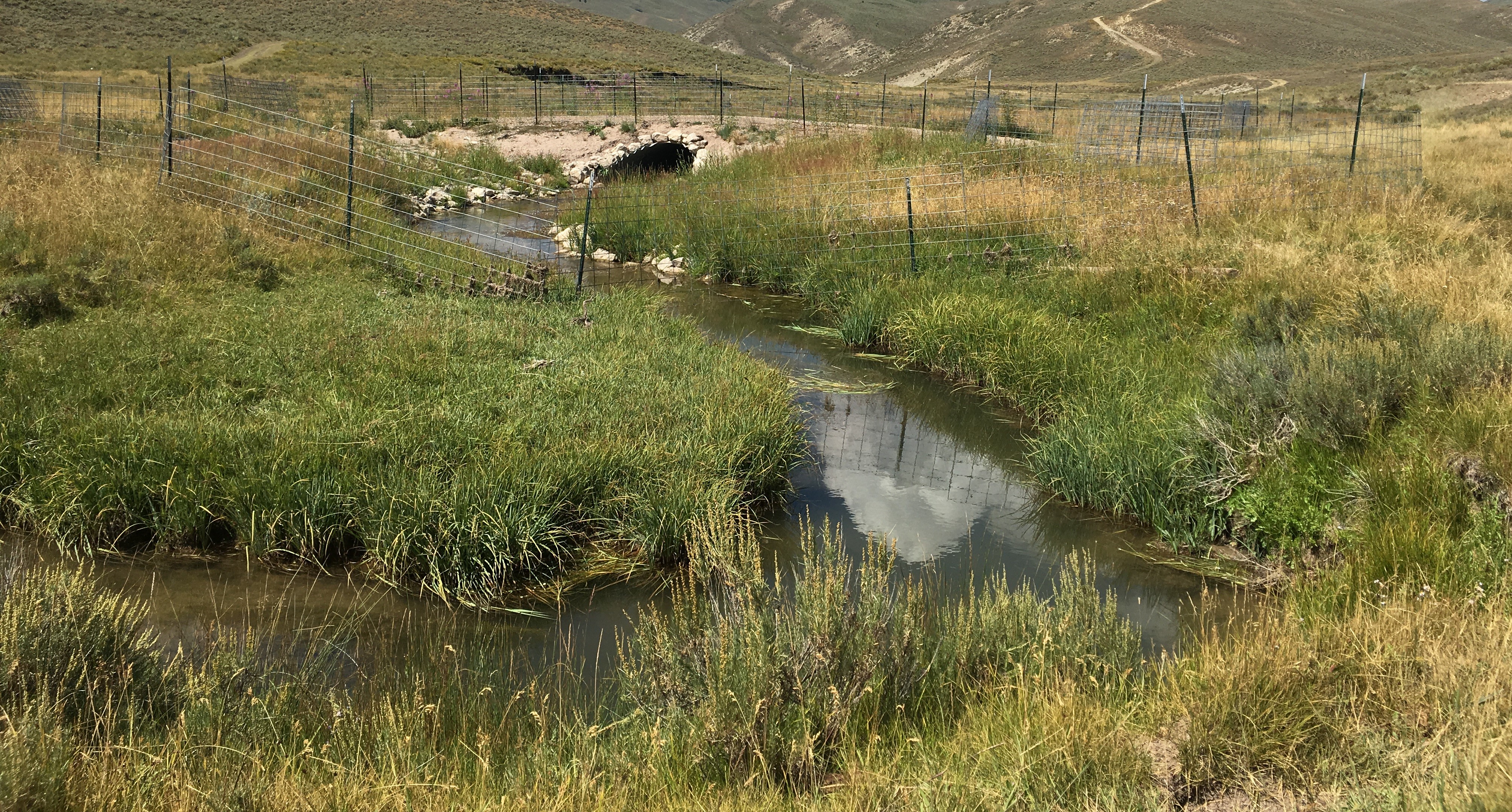
Coal Creek is a primary perennial tributary in the Thomas Fork River drainage, which contains a conservation population of migratory Bonneville Cutthroat Trout, a designated NSS3 species in Wyoming’s State Wildlife Action Plan. Bonneville cutthroat complete extensive inter-state migrations between the Bear River, the Thomas Fork, and small tributaries for spawning and rearing. In the 1990s, extensive tracking studies documented trout movements from the Bear River upstream through Idaho and into tributaries in Wyoming where the fish that survived the gauntlet of obstacles were able to spawn in small streams, including Coal Creek. Eliminating barriers and allowing expression of migratory life history tactics is important to the conservation of the species in the Bear River system. For some time, the Coal Creek Road had been recognized as a substantial sediment contributor in Coal Creek (Thomas Fork Habitat Management Plan [TFHMP] 1979, BLM National Riparian Service Team 1998). The creek also contained several undersized and perched culverts that impeded fish passage depending on flow conditions.
Aquatic habitats and stream function in Coal Creek had been degraded by high sediment loads from various sources. In particular, the Coal Creek Road (BLM Road #4216) was identified as a major contributor because portions of the road were constructed within the active floodplain, leading to excessive bank erosion and degraded fish habitat. Over time the creek had moved toward the road at numerous sites due to instability from livestock grazing. These conditions created erosion along the toe slopes of the road and caused high loads of sediment to flow directly into the stream. Realignment of the road and creek, runoff drainage remedies, bank stabilization, and re-vegetation and fencing was needed to resolve these problems.
Project summary:
National Fish Habitat Partnership funding was used to complete work to reduce sediment inputs into Coal Creek, an important Bonneville Cutthroat Trout (BCT) stream in western Wyoming. Aquatic habitats and stream function in Coal Creek and downstream in the Thomas Fork River, have been degraded by high sediment levels, contributed by a variety of sources. In particular, the Coal Creek Road has been identified as a major contributor because portions of the road were constructed within the active floodplain. The Project Goal was to address key habitat and connectivity threats to Bonneville Cutthroat Trout by reconnecting habitats and improving tributary habitats, enhancing the viability of Bonneville cutthroat populations, and supporting conservation of unique functioning habitat and life histories.
Objectives:
1) Reduce sediment loading;
2) Improve riparian and aquatic habitat condition and function;
3) Improve habitat for Bonneville Cutthroat Trout and other native fishes;
4) Maintain and enhance stream habitat connectivity;
5) Improve road function while reducing sediment contribution
This was accomplished by restoring riparian and upland vegetation, constructing bankfull benches and/or toe wood along meander bends to re-align the channel, completing necessary borrow ditch and road drainage upgrades, re-aligning and regrading the road, and reducing bank angles at ten remaining sites identified along a 2- mile section of Coal Creek Road.
Human Interest/Community Benefit:
Completion of this project greatly improved road access and safety for a variety of users. Livestock permittees travel this road routinely throughout the summer to tend and move their stock, and hunters and anglers use the road in summer and fall to access prime hunting and fishing spots. The undercut woody structures added to fix eroding banks also provide new trout habitat and places for anglers to target when they pursue their Wyoming Cutt Slam or Western Native trout Challenge. Agency personnel have received numerous positive comments about the road improvements since the project was completed in 2018.
Project Timeline:
Coal Creek Sediment Reduction and Bank Stabilization were completed in two phases. Phase I was constructed in 2015 and addressed fish passage at two historical crossings by replacing an undersized culvert and eroding vehicle ford with properly sized culverts that improve connectivity and stream function. Phase II was completed in 2018 and addressed road safety, bank stability and stream habitat for Bonneville Cutthroat Trout by performing stream restoration at 10 remaining sites where construction of Coal Creek Road within the active floodplain of Coal Creek had caused excessive erosion, impaired stream function, and degraded fish habitat.
Partners:
Wyoming Game and Fish Department (the lead organization)
Bureau of Land Management
Wyoming Landscape Conservation Initiative
Wyoming Wildlife and Natural Resource Trust
3Y Livestock
Wyoming Office of State Lands and Investments
Western Native Trout Initiative
Best weeks for site visits: The vegetation and overall watershed looks best (green riparian areas) in this part of Wyoming in June and early July each year.
Project Monitoring:
The Wyoming Game and Fish Department monitor fish and wildlife populations and habitat conditions and trends throughout this area at regular intervals, and Bonneville Cutthroat Trout populations will be evaluated in Coal Creek within five years of project completion. Wyoming Game and Fish will also use the Bank Assessment for Nonpoint source Consequence of Sediment (BANCS; Rosgen 2006) model for pre- and post-project monitoring to evaluate sediment contributions from each of the project sites.
Fixed monitoring locations for channel stability will be established. Monitoring will be done in at least two different years following bankfull or higher flows to document stability and performance of constructed features, the stream channel, and the road. Lateral and vertical measurements will be collected to document post-construction erosion rates. Photo points have also been established to document pre-project conditions and photos will be taken again in successive years.